Kilisut Harbor Restoration Project
We are excited to announce that the Kilisut Harbor Restoration project reached the milestone we’ve all been working toward since 2011 – Oak Bay is now reconnected to Kilisut Harbor! Click here for more information and photos.
Status: Completed.

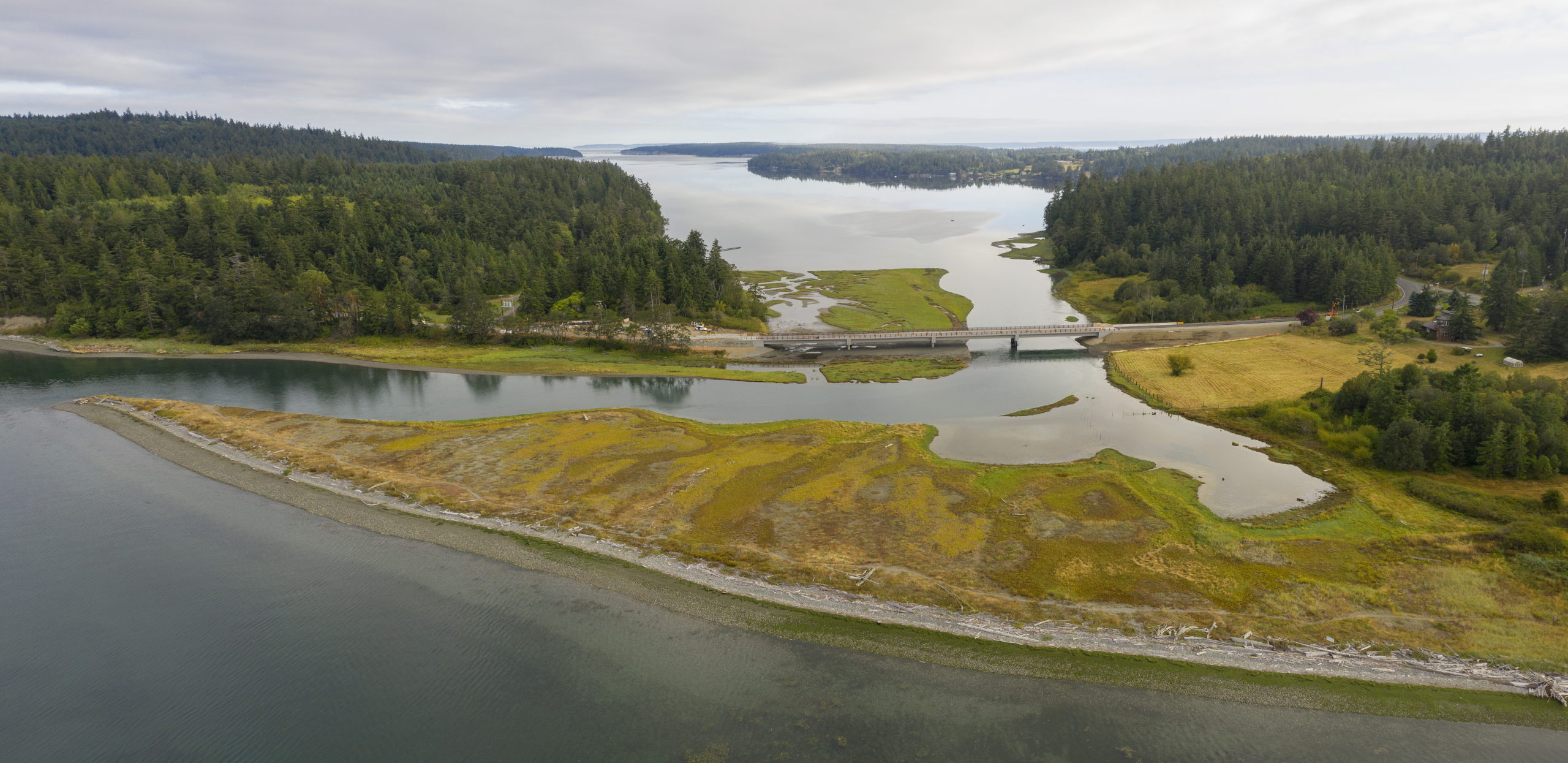
The newly opened channel between Oak Bay (bottom of image) and Kilisut Harbor (top) at high tide, with the new bridge connecting Indian Island on the left to Marrowstone Island on the right, image by John Gussman
The area between Indian and Marrowstone Islands was historically comprised of tidal channels and salt marsh. Tidal waters exchanged freely between Oak Bay and Kilisut Harbor, flushing cold water, moving sediment, and allowing juvenile salmon to migrate northward from Oak Bay into the shallow, productive waters of Kilisut Harbor. The installation of the causeway in between Kilisut Harbor and Oak Bay eased transportation between the Islands, but choked the flow of water and sediment, eventually creating an artificial beach berm, a filled channel, and increased water temperatures in Kilisut Harbor.
The Kilisut Harbor Restoration Project restores tidal connection between southern Kilisut Harbor (Scow Bay) and Oak Bay by removing the earthen causeway that contained two culverts. The causeway was replaced with a 440-foot bridge. These actions on WA State Route 116, restore natural processes and biological responses to 27 acres of marine intertidal habitat and tidal-fringe salt marsh that have been severely impacted by the construction of the earthen causeway.
This project benefits many species including salmon, shorebirds, waterfowl, shellfish and eelgrass, while also providing transport between the two islands. The bridge is being built to withstand earthquakes and storm surges where the causeway could not. The successful completion of this project will reconnect the large numbers of Hood Canal and Puget Sound out-migrating juvenile salmon that converge at Oak Bay with immense foraging opportunities available within Kilisut Harbor. The project will also restore and enhance important staging and foraging habitat for multiple coastal dependent and migratory birds. The greater Kilisut Harbor and Oak Bay areas have been identified as Important Bird Areas by the Washington Audubon Society, supporting up to 13,500 wintering shorebirds and waterfowl. Restoring the tidal flow between Kilisut Harbor and Oak Bay through salt marsh habitat will improve dissolved oxygen levels in Kilisut Harbor, thus improving overall water quality and conditions for shellfish.
Restoration in the Hoko Watershed
Status: Project designs have begun

Measuring the height of a culvert during an inventory project
An important aspect of salmon stock recovery is making sure that fish have access to the habitats they need for rearing and spawning. Culverts can often present barriers to fish passage for both juvenile and adult salmon. The importance of fish reaching the variety of functional habitat that they need has resulted in a statewide effort to remove an estimated 40,000 barriers in the state. North Olympic Peninsula Lead Entity for Salmon and the Brian Abbott Fish Barrier Removal Board have identified the Hoko River watershed as a top priority for the recovery of salmonids in Washington State. In 2019, NOSC completed one top ranked culvert removal project in the watershed at the mouth of Johnson Creek.
Currently, five more fish blocking culverts in the Hoko are being looked at for replacement. Replacing these culverts will help reconnect the Hoko to its native floodplain and allow fish access to over 46 acres of off-channel habitat for rearing, spawning, and protection during high flow events. Allowing rivers to connect with their floodplain also helps slow waters and recharge ground aquifers. Not only are these culvert replacements good for salmon, but they are also good for people by making our roads more resilient to storms.
NOSC is currently applying for funds to take on identified habitat restoration needs in the Hoko. We are engaged in grant processes seeking to restore mainstem and tributary habitat on the Hoko river.
Hoko Fish Passage Barrier Prioritization
Status: Culvert and habitat analysis currently underway.

The goal of the Hoko Fish Barrier Prioritization Project is to collect and analyze fish barrier and habitat data, in order to create a prioritized list of fish passage barriers for removal or replacement in the Hoko River watershed. The Hoko River sub basin has been identified by the Fish Barrier Removal Board as a top priority watershed for the recovery of salmonids in the Puget Sound region. This project will also help landowners by paying for the replacement or removal of failing or unwanted culverts that qualify. Clogged or failing culverts can cause road washouts, erosion, and flooding which is not good for humans or fish. If you are interested in discussing your culverts, contact NOSC at (360) 504-5611.
Johnson Creek Fish Passage Barrier Removal Project
Status: Completed 2019

The Johnson Creek culvert dug out and being removed by an excavator. This culvert was 200’ long, 12’ in diameter and below about 70’ of road fill. The pipe has been cut into section 20’ long for demolition. Each section looks like a giant soup can; these cans would hold about 1700 gallons of salmon chowder!
The Johnson Creek culvert, located in the Hoko Watershed in Clallam County, was a top ranked culvert removal/correction project by the Brian Abbott Fish Barrier Removal Board (FBRB) for the recovery of salmon in the Puget Sound region. FBRB is administered by Washington Department of Fish and Wildlife and the Recreation and Conservation Office. North Olympic Salmon Coalition was the Project Sponsor.
While there are many culverts on Johnson Creek this culvert was located right at the mouth, where it enters the Hoko River. Because it is so huge and such a risk to fish resources, it has become known simply as “The Johnson Creek Culvert.” This culvert was located just off Hoko Ozette Road, on a nearby logging mainline. The culvert was failing, beginning to send road fill into the Hoko, and was a barrier to fish passage. The greatest risk was of the culvert becoming completely clogged, which would have turned the 70 foot tall road fill into a dam, likely to fail and send the roadway directly into the Hoko River, to the detriment of the downstream habitat. To maintain the access to private timber land, a new bridge was constructed over Johnson Creek at an upstream location; and the culvert was dug out and removed with a massive excavator and continuously circling 6-wheel drive off-road dump trucks. A simplified creek channel has been reconstructed where the culvert was, once again allowing adult salmonids access to important spawning and rearing grounds. We expect the channel to recruit wood and sediment to set it on a path to looking more natural (adding such elements during construction at the bottom of the steep cut slopes was considered too risky for fear of encouraging erosion at the toe of the slope.) This project will reconnect 10.7 miles of fish habitat and 42 acres of forested wetlands, benefiting Chinook and coho salmon, steelhead, cutthroat trout and bulltrout. By preventing the road from failing and smothering downstream spawning grounds, the project also benefits pink and chum salmon.
To learn more about the FBRB and other priority projects click here!
Three Crabs Estuarine and Nearshore Restoration
Status: Completed 2016

The site of the old Three Crabs Restaurant and road a few months after construction.
Photo by John Gussman.
The 3 Crabs Nearshore and Estuarine Restoration Project removed infrastructure, fill and armoring at the site of the former 3 Crabs Restaurant. This project restored historic landforms and created public access at a newly established WDFW Wildlife Area along Dungeness Bay and Meadowbrook Creek, the last freshwater tributary to the Dungeness River, providing essential rearing habitat for outmigrating Dungeness River salmon. The Dungeness estuary and Dungeness Bay supports an average of 7,500 waterfowl (up to 13,000) during migration and winter. Estuarine and wetland habitat restoration here benefits a multitude of waterfowl species by improving access to a variety of habitat types. The ecological function of over 40 acres of coastal wetlands and ½ mile of stream channel have been restored. For a printable PDF of the self-guided site tour, please click here.
Sequim Bay Shoreline Restoration, USFWS Dawley
Status: Completed 2016

Bulkhead at Dawley Restoration site
The Dawley Restoration Project restored a 1,400 ft section of Sequim Bay shoreline owned by the United States Fish and Wildlife Service through the removal of armoring, bulkheads, fill, and overwater structures. The shoreline was re-contoured to blend into undisturbed adjacent beach faces and the marine riparian zone was re-vegetated. This project repairs habitat sustaining shoreline processes and improves migration and survival of juvenile salmon, especially Jimmycomelately Creek summer chum. Toxic creosoted pilings were removed, helping to improve water quality within Sequim Bay. The Dawley Phase alone removed approximate 5% of the bulkhead from the Sequim Bay shoreline, a major impairment to outmigrating juvenile salmon.

Before

AfterLower Discovery Bay Estuary Restoration at Snow Creek
Status: Completed 2015

Salmon and Snow Creek join and drain into Discovery Bay.
Restoration actions for the Lower Discovery Bay Estuary Restoration include removal and modification of an abandoned railroad grade removal of side cast dredge spoils and accumulated delta cone deposits. The Snow Creek Estuary Project restored approximately 11 acres of salt marsh and tidal channels along the banks of Snow Creek mouth. This area is critical habitat for ESA-listed Hood Canal Summer Chum. The Hood Canal Coordinating Council also released this interactive StoryMap which tells the story of Discovery Bay Restoration.


